
It was the second last day of our Georgia trip. We had booked a car for the next day to cross the border from Georgia to Armenia. I got a message from the driver, Iuri, that we would have to modify our plans slightly.
We were supposed to visit Haghpat monastery on the way to Dilijan. His message was exactly this, “Good evening. I wanted to warn you that the road to the Haghpat church is closed, we will go tomorrow only towards Dilijan. The road was washed away by the rain and the road there is blocked. I don’t know for how long, but I don’t think we can get there”.
Floods in Armenia
I searched on Google and found that the entire north of Armenia was affected and train services were suspended. The main highway between Georgia and Armenia had been washed away by the floods, the worst they had seen in more than a decade. The entire train system was also blocked. And we had to cross over the next day!
The first question in my mind was – would we still be able to take the same route? I checked Google maps and it said the Sadakhlo-Bagratashen border – the main one – was blocked and we had to take another border crossing which was a huge detour. I messaged Iuri again checking this and he was confident that we could use the same main border and take a detour. There was no trouble at all even though the main highway had been washed away by the flood – that’s what he insisted.
The journey begins in Tbilisi
Iuri met us at the place where we dropped off our Subaru in Tbilisi. He welcomed us with a warm smile and was talkative. I had found him on a website called GoTrip. You can find drivers in Georgia based on the type of car and the languages that they speak. Iuri had great ratings and he could speak English fluently. He had a lot of fun with the kids and kept calling them “hooligans” when they stood up on the seats while he was driving.
We made a quick stop at a McDonalds in the outskirts of Tbilisi. Parth recognized that this was the place to get french fries and made us get one! It’s amazing how consistent the branding of McDonalds is throughout the world – it is truly a globally standardized experience!
Arab flavors near the border
The route went along a bunch of small towns. Iuri told us that this area was close to the border of Azerbaijan as well and there was a significant population of Azerbaijanis here. The Arab influence was clearly visible in the eateries – the Khinkhali and Khachapuri sign boards were now replaced with Shawarmas and Kebabs. There were also a lot of Turkish names and boards closer to the border town of Sadakhlo.
Immigration experience at the land border
Soon, we rolled into the border crossing. We left our luggage inside the car and walked over to the immigration office. It looked like an airport immigration counter and the process was similar. No questions were asked and they stamped us out. We got back into the car and drove across the Debed river (the one which flooded) which acts as the natural border between the two countries. We said goodbye to the giant Georgian flag.

The Armenian border immigration was a lot less fancy. There was no AC and the building itself seemed old and worn out. There were military officers sitting at the counters unlike the women in suits on the Georgian side. We were a bit worried and hoped that they would clear us. We had all our documents printed and ready in case they asked. Thankfully, they only looked at our e-Visa and sent us through without any questions. We had to carry all our luggage by hand and get it scanned before reloading onto our car. It took less than 30 mins to complete both immigration counters.
The flag of Armenia was one of the most unique we’d seen till now. The color combination was unique – red, blue and orange. They call it the Tricolor as well (similar to India).
After immigration, we stopped at a shop to convert currency. Our first order of action after getting the Armenian Dram was to buy a SIM card – we took Viva-MTS, a 10 GB data pack for 2500 AMD (INR 540).
Alternate route due to the floods
The Debed river was starting to get much stronger as we entered Armenia. Some portions of the road had been washed away and trees on the river bank were lying uprooted. Soon, we took a deviation away from the river and that highway towards the town of Haghtanak.
We were now on a different route, this was the old Tbilisi-Yerevan highway that went through Noyemberyan and Ijevan. The route passed through a lot of mountains and the road kept twisting and turning. Google Maps absolutely refused to show this route because some parts of it went through disputed territory with Azerbaijan. The only map which did show this route correctly was Maps.me – the best map app in the former Soviet nations.
The original plan was to stop at Ijevan for lunch. As we neared Ijevan, I looked back and saw everyone, including the kids, sleeping. I told Iuri to go straight to Dilijan without any stops. We would eat once we got there since it was only 35 mins away.
As we got closer to Dilijan, we could see some parts of this highway washed away by the Aghstev river. We didn’t have any roadblocks, so it didn’t really affect us. The weather had been good so far without much rain. Soon, we said goodbye to Iuri (and he said bye to our “hooligan” travel companions) and checked into our unique Hobbit hotel!
Hobbit town
One of the highlights of our Dilijan experience was the hotel we stayed in. Each room was designed as a hobbit hole (from Lord of the Rings) and the entire place looked like the Shire. We had fun opening and closing the round wooden doors! We spent the evening relaxing at the hotel while the kids played in the park.

Next morning, after breakfast, we saw a man dressed in a white shirt and black trousers and sunglasses standing with arms crossed near the gate. He looked like a secret agent! The hotel manager said he was waiting for us. This was Zaven, our driver from Hyur Service. He would take us to visit Haghartsin monastery, Dilijan town, Sevan lake and then drop us off at Yerevan.
The hidden monastery
The Haghartsin monastery stood in the middle of a dense forest on top of a hill. It could only be seen once we got there! It was a beautiful structure which had 3 churches inside.


On the way back downhill, we could hear a brook babbling nearby. We asked Zaven to stop at a point where we could access it. There were many picnic spots created so that the locals could come out and have a nice time with their families. The kids had fun playing in the water.

Quaint old Dilijan
Next stop was Dilijan town. Dilijan is known as the Switzerland of Armenia for its natural beauty. While we couldn’t visit the national park, we did get a good taste of it so far. We walked down the old Sharambeyan street – the most famous street of the town, bought souvenirs and checked out the craft workshops.

For lunch, we found a few really good options. Since we could only pick one, we went to Cafe #2, a cute little cafe next to Dilijan lake. The food was really nice and it felt good to have burgers after a long time! This is one place I would love to come again just to sit for hours and probably write something.


To travel within Dilijan, you can use the Yandex app. We could find plenty of cabs available on the app but didn’t have the need to use them since we were only there for a day.
Tummies full, we started on our drive to Sevan lake. On the way, we saw tons of “sweet corn” stalls along the highway. Most of them were shut but corn seemed to be a big thing here.
The giant Sevan lake
The road to Sevan was really smooth. It looked nothing like what I remember seeing on that Malayalam Youtube channel a few years back. I guess the story-telling and time of the year made it seem more isolated than it really was.

Zaven drove straight to the Sevanavank monastery.
The monastery stood on top of a hill. Both kids were sleeping and the moms were not in the mood to wake them up for an uphill hike. So, Ashwin and I went ahead to explore the monastery. The weather was really nice and perfect for the hike. The inside of the monastery was really cool – the architecture of these ensured that it remained cool even in peak summers.
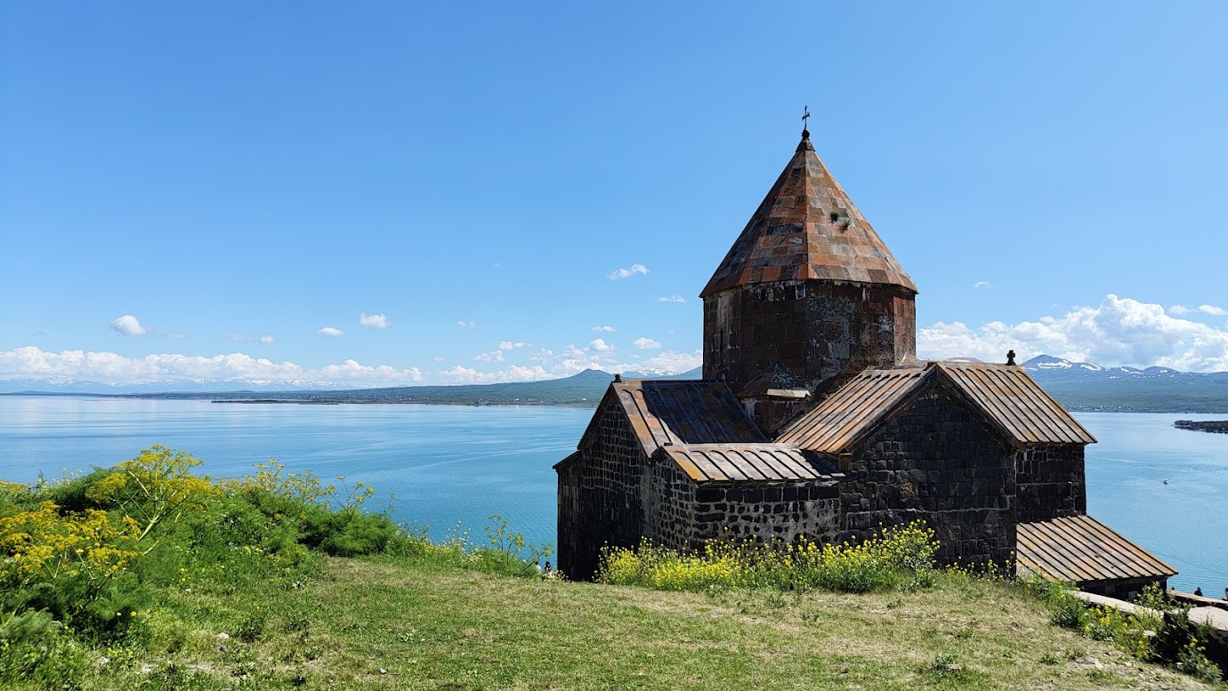
When we reached the top, the main attraction took over – the lake itself! It was HUGE! In fact, it is the largest water body in the entire Caucasus region and occupies one-sixth of Armenia. The skies were blue and made the lake look even more beautiful. There were snow capped peaks in the distance on the other side of the lake. After a lot of photography and standing there enjoying the view, we headed back.
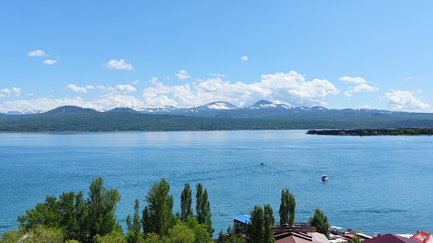
The lake also has beaches – the only beaches in Armenia as the country is landlocked. The water was ice-cold though. We spent some time there as well and then started on our journey to Yerevan.
You can find all the Armenia blogs here:
- The Armenia Itinerary – plan you perfect trip to Armenia
- Crossing over a land border to Dilijan – the Switzerland of Armenia
- Yerevan and Etchmiadzin – the oldest cathedral in the world
If you enjoyed reading this blog, do subscribe, it is free. Leave a comment below if or on our Instagram if you want any tips on planning your trip.
Discover more from FridgeMagnet Tales
Subscribe to get the latest posts sent to your email.
2 thoughts on “Crossing a land border to Dilijan – the Switzerland of Armenia”